Norway Topo Maps
Sadržava oglaseKupovina unutar aplikacije
4,1star
741 recenzijainfo
50 hilj.+
Preuzimanja

PEGI 3
info

O aplikaciji
+++ NEW ! Introductory Price ! Get the full features for a small one time fee +++
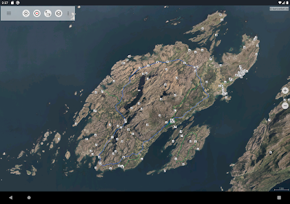
Easy to use Outdoor/Offline GPS navigation app with access to the best topographic maps and satellite images for Norway.
++ For offline use PRO features needed ! ++
Turn your Andoid Phone/Tablet into an outdoor GPS for trips into the backcountry WITHOUT CELL COVERAGE. See your position on different maps, record your track or share your location with others.
Included FREE Base Map Layers:
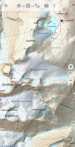
• Topographic Map 1:50.000 for complete Scandinavia ( Denmark, Norway, Sweden und Finland) with hillshading.
• Norway Base Map: Best available and up to date official maps from Kartverket.no (colored and greyscale as basemap for overlays)
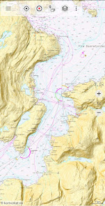
• Norway official RNC Nautical Charts
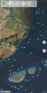
• Norway Seefloor Terrain Map
• Norway Historical Maps
• OpenStreetMaps : These crowdsourced maps are a very useful addition to other map layers. Contains many unique features.
• OpenCycleMaps: These maps are ideal to plan bicycle trips (PRO Users only !)
• ESRI Topographic
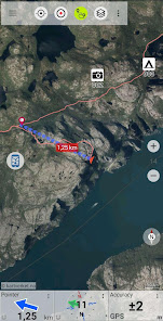
• ESRI Aerial Images
• ESRI Street Map
• Google Road Map (online access only)
• Google Satellite Images (online access only)
• Google Terrain Map (online access only)
• Bing Road Map (online access only)
• Bing Satellite Images (online access only)
• Earth At Night
Overlay Map Layers:
• Trekking-, Bycycle and Cross-Country-Ski Routes
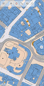
• Cadastre Map with building footprints
• Lake Depths
• River network
• Hillshading
Main features for outdoor-navigation:
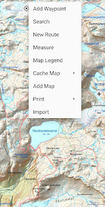
• Create and edit Waypoints
• GoTo-Waypoint-Navigation
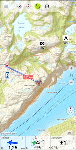
• Track Recording (with speed, elevation and accuracy profile)
• Tripmaster with fields for odometer, average speed, bearing, elevation, etc.
• GPX/KML/KMZ Export
• Search (placenames, POIs, streets)
• Customizable datafields in Map View and Tripmaster (e.g. Speed, Distance, Compass, ...)
• Share Waypoints, Tracks or Routes (via eMail, Whatsapp, Dropbox, Facebook, ..)
• Display coordinates in Lat/Lon, UTM or MGRS/USNG (Military Grid/ US National Grid)
• Record & share tracks with statistics & elevation profile
• Rotate map (Track Up & North Up)
• Get Elevation and Distance by long click on map
• Track Replay
• Add custom map tile servers
• and many more ...
Available Pro features: (Pro features available via In App Purchase)
• Offline Use - no cell coverage needed. No Roaming fees !
• Easy+Fast Bulk-download of map tiles for OFFLINE USAGE (not for Google and Bing maps)
• Create and edit Routes
• Route-Navigation (Point-to-Point Navigation)
• GPX/KML/KMZ Import/Export
• unlimited Waypoints & Tracks
• Add other Map Tile-Server
• No Ads
Offline Use:
All viewed map tiles are kept in cache. To cache large areas you need to purchase Pro features.
Use this navigation app for outdoor activities like hiking, biking, camping, climbing, riding, skiing, canoeing, hunting, offroad 4WD tours or search&rescue (SAR).
Add custom waypoints in longitude/latitude, UTM or MGRS/USNG format with WGS84 datum.
Import/Export/Share GPS-Waypoints/Tracks/Routes in GPX or Google Earth KML/KMZ format.
Preload FREE map data for areas without cell service (Pro feature !).
Comments and feature requests to [email protected]
Have a look at our other outdoor navigation apps: /store/search?q=atlogis
+++ We DO NOT track any user activities or collect any user data ! +++
Easy to use Outdoor/Offline GPS navigation app with access to the best topographic maps and satellite images for Norway.
++ For offline use PRO features needed ! ++
Turn your Andoid Phone/Tablet into an outdoor GPS for trips into the backcountry WITHOUT CELL COVERAGE. See your position on different maps, record your track or share your location with others.
Included FREE Base Map Layers:
• Topographic Map 1:50.000 for complete Scandinavia ( Denmark, Norway, Sweden und Finland) with hillshading.
• Norway Base Map: Best available and up to date official maps from Kartverket.no (colored and greyscale as basemap for overlays)
• Norway official RNC Nautical Charts
• Norway Seefloor Terrain Map
• Norway Historical Maps
• OpenStreetMaps : These crowdsourced maps are a very useful addition to other map layers. Contains many unique features.
• OpenCycleMaps: These maps are ideal to plan bicycle trips (PRO Users only !)
• ESRI Topographic
• ESRI Aerial Images
• ESRI Street Map
• Google Road Map (online access only)
• Google Satellite Images (online access only)
• Google Terrain Map (online access only)
• Bing Road Map (online access only)
• Bing Satellite Images (online access only)
• Earth At Night
Overlay Map Layers:
• Trekking-, Bycycle and Cross-Country-Ski Routes
• Cadastre Map with building footprints
• Lake Depths
• River network
• Hillshading
Main features for outdoor-navigation:
• Create and edit Waypoints
• GoTo-Waypoint-Navigation
• Track Recording (with speed, elevation and accuracy profile)
• Tripmaster with fields for odometer, average speed, bearing, elevation, etc.
• GPX/KML/KMZ Export
• Search (placenames, POIs, streets)
• Customizable datafields in Map View and Tripmaster (e.g. Speed, Distance, Compass, ...)
• Share Waypoints, Tracks or Routes (via eMail, Whatsapp, Dropbox, Facebook, ..)
• Display coordinates in Lat/Lon, UTM or MGRS/USNG (Military Grid/ US National Grid)
• Record & share tracks with statistics & elevation profile
• Rotate map (Track Up & North Up)
• Get Elevation and Distance by long click on map
• Track Replay
• Add custom map tile servers
• and many more ...
Available Pro features: (Pro features available via In App Purchase)
• Offline Use - no cell coverage needed. No Roaming fees !
• Easy+Fast Bulk-download of map tiles for OFFLINE USAGE (not for Google and Bing maps)
• Create and edit Routes
• Route-Navigation (Point-to-Point Navigation)
• GPX/KML/KMZ Import/Export
• unlimited Waypoints & Tracks
• Add other Map Tile-Server
• No Ads
Offline Use:
All viewed map tiles are kept in cache. To cache large areas you need to purchase Pro features.
Use this navigation app for outdoor activities like hiking, biking, camping, climbing, riding, skiing, canoeing, hunting, offroad 4WD tours or search&rescue (SAR).
Add custom waypoints in longitude/latitude, UTM or MGRS/USNG format with WGS84 datum.
Import/Export/Share GPS-Waypoints/Tracks/Routes in GPX or Google Earth KML/KMZ format.
Preload FREE map data for areas without cell service (Pro feature !).
Comments and feature requests to [email protected]
Have a look at our other outdoor navigation apps: /store/search?q=atlogis
+++ We DO NOT track any user activities or collect any user data ! +++
Ažurirano dana
Sigurnost počinje razumijevanjem na koji način programeri prikupljaju i dijele vaše podatke. Privatnost podataka i sigurnosne prakse se mogu razlikovati ovisno o korištenju, regiji i dobi. Programer je naveo ove informacije i može ih s vremenom ažurirati.

Ova aplikacija može dijeliti ove vrste podataka s trećim stranama
Lične informacije, Aktivnost aplikacija i još 2

Podaci se ne prikupljaju
Saznajte više o načinu na koji programeri pružaju izjavu o prikupljanju

Podaci se šifriraju tokom prenosa

Možete zatražiti da se podaci izbrišu
Ocjene i recenzije
4,0
670 recenzija
Što je novo
・Shapes: Import shapes from shape files, geojson or kmz
・Android 15 support
・Fixes
・Android 15 support
・Fixes
Podrška za aplikaciju
Informacije o programeru
Atlogis Geoinformatics GmbH & Co. KG
Unter den Ulmen 8
33330 Gütersloh
Germany
+49 171 1738949


