
Russian Topo Maps
Contains ads
4.2star
64.8K reviewsinfo
5M+
Downloads

PEGI 3
info


About this app
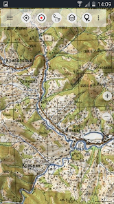
Offroad navigation app with worldwide topographic maps (mainly Russian general staff maps). There are also many other map layers with up-to-date and detailed maps or aerial photos.
Even though most of the Russian maps date back to the 1980s, they are still among the best topo maps available for many regions in Africa and Asia, especially if you are looking for remote tracks or old infrastructure. All maps are also labelled in English.
Map data can be downloaded so that the application can also be used without internet reception. No user data is collected by the app!
Selectable map layers (worldwide):
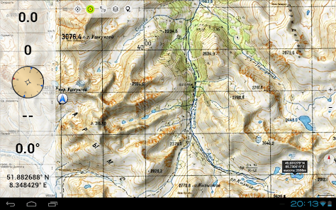
• Topo maps (worldwide coverage 1:100,000 - 1:200,000) Russian General Staff maps - Genshtab
• GGC Gosgiscentr Topo maps Russia 1:25,000 - 1:200,000
• ROSREESTR The Federal Service for State Registration, Cadastre and Cartography (only Russia. Up-to-date and very detailed)
• Yandex Maps: Satellite images, road map. (Online use only!)
• Openstreetmap: excellent maps with different styles as well as shading & contour lines): OSM Topo, OSM Cycle Map (especially for cyclists), OSM Outdoors (for hikers), OSM Landscape
• Google Maps: Satellite images, road and terrain maps. (Online use only!)
• Bing Maps: Satellite images and street map. (Online use only !)
• ESRI Maps: Satellite images, street and terrain map.
All maps can be created as overlays and compared with each other using a transparency slider.
Switchable overlays (worldwide):
• Hillshading
• 20m contour lines
- OpenSeaMap
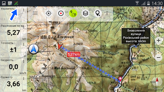
This app offers all functions for comprehensive outdoor navigation:
• Download of maps for OFFLINE operation (except Google, Bing & Yandex Maps)
• Create waypoints
• GoTo waypoint navigation
• Create and navigate routes (with automatic route calculation based on OpenStreetMaps)
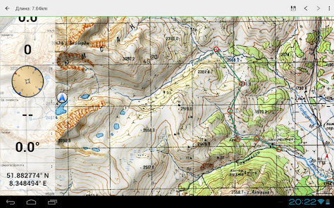
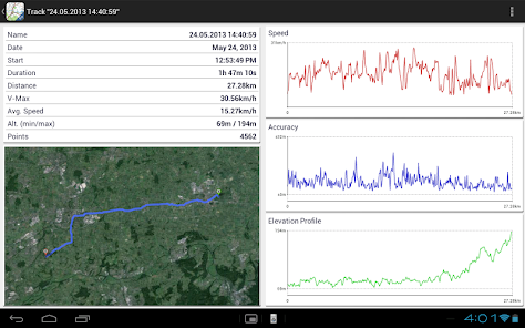
• Track recording (evaluation with speed and altitude profile)
• Freely configurable data fields in the map view (e.g. speed, altitude)
• Tripmaster with fields for daily kilometres, average, distance, compass, etc.
• GPX/KML/KMZ import export
• Search function (locations, POIs, street names)
• Waypoint/track sharing (via e-mail, WhatsApp, ...)
• Measurement of paths and areas
• UMTS/MGRS GRID
Other maps can be imported in common formats:
• GeoPDF
• GeoTiff
• MBTiles
• Ozi (Oziexplorer OZF2 & OZF3)
• Online map services can be integrated as WMS servers or XYZ tile servers.
• OpenStreetMap maps can also be downloaded country by country in space-saving vector format!
LIMITATIONS OF THIS FREE VERSION:
• Ads
• Max. 10 Waypoints
• Max. 5 Tracks
• No import/export of waypoints/tracks/routes
• No import of maps (WMS, GeoTiff, GeoPDF, MBTiles)
• No Cache download for offline use
• No Local City DB (Offline Search)
• No Route navigation
For questions please contact [email protected]
Even though most of the Russian maps date back to the 1980s, they are still among the best topo maps available for many regions in Africa and Asia, especially if you are looking for remote tracks or old infrastructure. All maps are also labelled in English.
Map data can be downloaded so that the application can also be used without internet reception. No user data is collected by the app!
Selectable map layers (worldwide):
• Topo maps (worldwide coverage 1:100,000 - 1:200,000) Russian General Staff maps - Genshtab
• GGC Gosgiscentr Topo maps Russia 1:25,000 - 1:200,000
• ROSREESTR The Federal Service for State Registration, Cadastre and Cartography (only Russia. Up-to-date and very detailed)
• Yandex Maps: Satellite images, road map. (Online use only!)
• Openstreetmap: excellent maps with different styles as well as shading & contour lines): OSM Topo, OSM Cycle Map (especially for cyclists), OSM Outdoors (for hikers), OSM Landscape
• Google Maps: Satellite images, road and terrain maps. (Online use only!)
• Bing Maps: Satellite images and street map. (Online use only !)
• ESRI Maps: Satellite images, street and terrain map.
All maps can be created as overlays and compared with each other using a transparency slider.
Switchable overlays (worldwide):
• Hillshading
• 20m contour lines
- OpenSeaMap
This app offers all functions for comprehensive outdoor navigation:
• Download of maps for OFFLINE operation (except Google, Bing & Yandex Maps)
• Create waypoints
• GoTo waypoint navigation
• Create and navigate routes (with automatic route calculation based on OpenStreetMaps)
• Track recording (evaluation with speed and altitude profile)
• Freely configurable data fields in the map view (e.g. speed, altitude)
• Tripmaster with fields for daily kilometres, average, distance, compass, etc.
• GPX/KML/KMZ import export
• Search function (locations, POIs, street names)
• Waypoint/track sharing (via e-mail, WhatsApp, ...)
• Measurement of paths and areas
• UMTS/MGRS GRID
Other maps can be imported in common formats:
• GeoPDF
• GeoTiff
• MBTiles
• Ozi (Oziexplorer OZF2 & OZF3)
• Online map services can be integrated as WMS servers or XYZ tile servers.
• OpenStreetMap maps can also be downloaded country by country in space-saving vector format!
LIMITATIONS OF THIS FREE VERSION:
• Ads
• Max. 10 Waypoints
• Max. 5 Tracks
• No import/export of waypoints/tracks/routes
• No import of maps (WMS, GeoTiff, GeoPDF, MBTiles)
• No Cache download for offline use
• No Local City DB (Offline Search)
• No Route navigation
For questions please contact [email protected]
Updated on
Safety starts with understanding how developers collect and share your data. Data privacy and security practices may vary based on your use, region and age. The developer provided this information and may update it over time.

This app may share these data types with third parties
Device or other IDs

No data collected
Learn more about how developers declare collection

Data is encrypted in transit

You can request that data be deleted
Ratings and reviews
4.2
60.6K reviews

Olweny Pa' Okello
- Flag inappropriate
- Show review history
3 May 2021
I used app' in 2016,it is good user friendly interface.However the developer should improve on grid accuracies, waypoints activation which exceeds more than 3 positions on the map,it embarrasses bcoz of limited savings of user's points on the map.improve on, make it a 4or 5 generation map, allow it to use satellites aerial map.
68 people found this review helpful

A Google user
- Flag inappropriate
7 July 2019
It is amazing map! Very detailed maps(but with time some details changed of course). This app is reliable and accurate, nice thing for traveling, you can found some interesting places or you can plan details of your trip knowing the topography of area.
68 people found this review helpful

ARHROUD Anas
- Flag inappropriate
30 April 2025
Great Map lot of options, but In the African map, Morocco is now one territory part so there is no western sahara.
1 person found this review helpful
What's new
・Android 15 support
・Bug fixes & Improvements
・Bug fixes & Improvements
App support
About the developer
Atlogis Geoinformatics GmbH & Co. KG
Unter den Ulmen 8
33330 Gütersloh
Germany
+49 171 1738949


