
Mazury
In-app purchases
5+
Downloads

PEGI 3
info


About this app
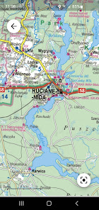
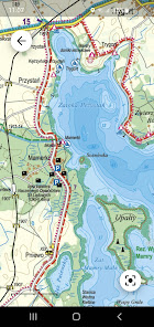
A cruise on Lake Śniardwy, a bicycle trip around Lake Łuknajno, or maybe a visit to the Boyen Fortress in Giżycko? It's hard to get bored in Masuria. Our tourist sailing map will be helpful in discovering the charms of this land. The publication was prepared in cooperation with local experts from the region. It is characterized by rich tourist content, including sailing.
• hiking and cycling trails, educational and walking trails, kayaking trails, passenger shipping lines,
• cardinal signs, marked fairway,
• height of clearances under bridges, overhead power lines on the navigable route,
• masts of the warning signaling system for sailors,
• isobaths showing the depths of the lakes (isobaths are drawn every 10 m, additionally, isobaths of 1, 2 and 5 m, which are very important for sailors, are shown), supplemented by colored bathymetry,
• depths of lakes, obstacles and shoals, locks, marinas and piers, gas stations for yachts,
• silence zones, prohibitions on coming to the shore,
• hotels, campsites, water stations
• museums, monuments, bunkers and other interesting objects
• landscape parks, nature reserves, natural attractions
• contour lines showing the terrain.
The application displays your position on the map and allows you to change the map's magnification and detail.
After purchasing the full version of the application, you will have access to the entire map.
You can check the full coverage of the Masuria map here: https://mapymapy.pl/zasiegi/Mazury...._map_aAPK_PL.html
Updated on
Safety starts with understanding how developers collect and share your data. Data privacy and security practices may vary based on your use, region, and age. The developer provided this information and may update it over time.

No data shared with third parties
Learn more about how developers declare sharing

This app may collect these data types
Personal info, App activity and 2 others

Data is encrypted in transit

Data can’t be deleted
What’s new
Drobne poprawki i usprawnienia aplikacji
App support
About the developer
EXPRESSMAP POLSKA SP Z O O
1-11 Ul. Jeździecka
01-461 Warszawa
Poland
+48 502 513 001


