Footpath Route Planner
In-app purchases
4.6star
7.94K reviewsinfo
500K+
Downloads

PEGI 3
info
About this app
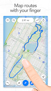
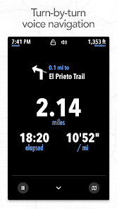
Trace a map with your finger and Footpath will snap to roads and trails. Measure distance and elevation in seconds, then follow along with turn-by-turn voice navigation.
Mix up your routine and plan out a new running route or bike ride, or plan a scenic road trip or multi-day hiking adventure. Footpath allows you to plan custom routes quicker and easier than ever before.
Join millions of adventurers using Footpath Route Planner and pave your own path.
Snap to map
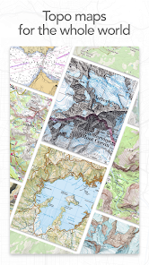
Quickly measure distances by tracing a map with your finger. Footpath will snap to any roads, bike paths, hiking trails, or paths you can find on Footpath's topo maps. Footpath can even snap to rivers and railroads.
Measure distance and elevation
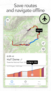
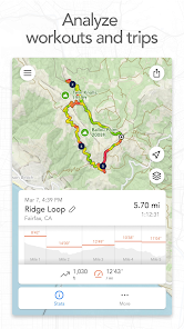
Know exactly how far and how high you'll travel with an accurate distance measure and detailed elevation profiles. Plan a precise route that matches your mileage goal, or use as a GPS distance tracker if you run without a plan.
Save routes for later
Marathon training or planning a backpacking trip? Sign up for a free account to save up to 5 routes at a time, or save an unlimited number of routes with Footpath Elite.
GPX viewer
Find a cool hiking trail on the web? Import GPX files from anywhere to analyze or save for later.
Share routes
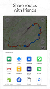
Send your routes to friends or workout partners and let them partake in your adventure.
Footpath is designed to work in any country, and for any activity or adventure you can imagine:
• Running, walking, and hiking
• Cycling and mountain biking
• Motorcycling and driving
• Kayaking, canoeing, and standup paddleboarding
• Backcountry skiing
• Sailing
• And many more!
———
Ready to go the extra mile? Upgrading to a Footpath Elite subscription unlocks the following powerful features:
• Turn-by-turn navigation: Footpath will tell you when to turn with turn-by-turn audio cues
• Premium topo maps & overlays: including USGS Topo Maps, OpenCycleMap, bike paths, avalanche slope shading, elevation contour lines, and many more
• Offline map downloads: follow your route even without cell service
• Organize: save unlimited routes and sort routes into custom lists
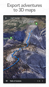
• Export: export GPX files directly to Garmin Connect, Wahoo ELEMNT, COROS, and other apps
• GPS Devices: export TCX and FIT courses for turn-by-turn navigation on select Garmin and Wahoo running watches and cycling computers
———
• For a longer route, try zooming in and mapping your route in multiple segments.
• Tap and hold the map to quickly route between waypoints and POIs.
• Did Footpath snap to the wrong roads? Trace over the incorrect segment to edit, or use the eraser tool.
• Turn off snap to roads (magnet icon) and zoom in to manually trace the map. (Try switching to a satellite layer).
———
We've got a lot planned for Footpath. If you have any suggestions or feedback, or if you run into any issues, please contact us at [email protected].
Mix up your routine and plan out a new running route or bike ride, or plan a scenic road trip or multi-day hiking adventure. Footpath allows you to plan custom routes quicker and easier than ever before.
Join millions of adventurers using Footpath Route Planner and pave your own path.
Snap to map
Quickly measure distances by tracing a map with your finger. Footpath will snap to any roads, bike paths, hiking trails, or paths you can find on Footpath's topo maps. Footpath can even snap to rivers and railroads.
Measure distance and elevation
Know exactly how far and how high you'll travel with an accurate distance measure and detailed elevation profiles. Plan a precise route that matches your mileage goal, or use as a GPS distance tracker if you run without a plan.
Save routes for later
Marathon training or planning a backpacking trip? Sign up for a free account to save up to 5 routes at a time, or save an unlimited number of routes with Footpath Elite.
GPX viewer
Find a cool hiking trail on the web? Import GPX files from anywhere to analyze or save for later.
Share routes
Send your routes to friends or workout partners and let them partake in your adventure.
Footpath is designed to work in any country, and for any activity or adventure you can imagine:
• Running, walking, and hiking
• Cycling and mountain biking
• Motorcycling and driving
• Kayaking, canoeing, and standup paddleboarding
• Backcountry skiing
• Sailing
• And many more!
———
Footpath Elite
Ready to go the extra mile? Upgrading to a Footpath Elite subscription unlocks the following powerful features:
• Turn-by-turn navigation: Footpath will tell you when to turn with turn-by-turn audio cues
• Premium topo maps & overlays: including USGS Topo Maps, OpenCycleMap, bike paths, avalanche slope shading, elevation contour lines, and many more
• Offline map downloads: follow your route even without cell service
• Organize: save unlimited routes and sort routes into custom lists
• Export: export GPX files directly to Garmin Connect, Wahoo ELEMNT, COROS, and other apps
• GPS Devices: export TCX and FIT courses for turn-by-turn navigation on select Garmin and Wahoo running watches and cycling computers
———
Tips for mapping routes
• For a longer route, try zooming in and mapping your route in multiple segments.
• Tap and hold the map to quickly route between waypoints and POIs.
• Did Footpath snap to the wrong roads? Trace over the incorrect segment to edit, or use the eraser tool.
• Turn off snap to roads (magnet icon) and zoom in to manually trace the map. (Try switching to a satellite layer).
———
Contact Us
We've got a lot planned for Footpath. If you have any suggestions or feedback, or if you run into any issues, please contact us at [email protected].
Updated on
Safety starts with understanding how developers collect and share your data. Data privacy and security practices may vary based on your use, region, and age. The developer provided this information and may update it over time.

No data shared with third parties
Learn more about how developers declare sharing

This app may collect these data types
Location, Personal info and 3 others

Data is encrypted in transit

You can request that data be deleted
Ratings and reviews
4.6
7.63K reviews

R Dub
- Flag inappropriate
November 16, 2024
It's everything I wanted in a route planner for hiking. Simple and reasonably intuitive. The map itself is very accurate and the GPS accuracy is excellent. (looking at you, google maps....) Being able to draw routes with your finger straight into the app saves having to map on PC and export to phone, although you can do this too. Elevation profile is awesome. Calculates time based on adjustable average speed. These are just free features, I will definitely look into upgrading this awesome app.
21 people found this review helpful

Matt Mills
- Flag inappropriate
July 5, 2025
initial experience is good over a known 20 mile route on the North York Moors. I'm planning to use this instead of my os maps subscription for my upcoming Wainwright's c2c in August however I have a few small reservations: the 24 hr time limit on downloaded os maps is a concern - could do with a better explanation on that as a multi-day hike with no signal could be endex for me! Good job on the turn by turn voice btw, works great offline with Bluetooth headsets. could do with a better home page.
7 people found this review helpful

Christopher Anderson
- Flag inappropriate
April 14, 2025
Dropped a star, as trying to make a route map for walking, half way through the line would not continue down some steps ( but they are marked on the map) , instead the line jumped to a path going in the opposite direction, then doubled back to the bottom of the steps, a route 3 times longer ,the strange thing is the line has gone down steps on other maps I've made . Overall a good App.
7 people found this review helpful
What’s new
- Re-designed topo maps (Footpath Elite)
- Public transit map overlay (Footpath Elite)
- Bug fixes
If you're enjoying Footpath, please help us out by writing a review on the Play Store.
If you have any problems or suggestions, send us an email at [email protected].
- Public transit map overlay (Footpath Elite)
- Bug fixes
If you're enjoying Footpath, please help us out by writing a review on the Play Store.
If you have any problems or suggestions, send us an email at [email protected].
App support
About the developer
Half Mile Labs LLC
440 N Barranca Ave
Covina, CA 91723
United States
+1 213-863-4560


