
GPS Logger
4.5star
2.82K reviewsinfo
500K+
Downloads

PEGI 3
info

About this app
BasicAirData GPS Logger is a simple App for recording your position and your path.
It's a basic and lightweight GPS tracker focused on accuracy, with an eye to power saving.
It works offline (without internet connection), it has NO integrated maps.
This app is very accurate in determining the orthometric height (the altitude above sea level), if you enable EGM96 altitude correction on settings.
You can record all your trips, view them with any installed external viewer, directly from the in-app tracklist, and share them in KML, GPX, and TXT format in many ways.
The app is 100% Free and Open Source.
GETTING STARTED GUIDE:
https://www.basicairdata.eu/projects/android/android-gps-logger/getting-started-guide-for-gps-logger/
IT FEATURES:
- A modern UI, with a low consumption dark theme and a tabbed interface
- Offline recording (the app has no integrated maps)
- Foreground & Background Recording (On Android 6+ please turn off all battery monitoring and optimizations for this app)
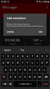
- Creation of annotations also meanwhile recording
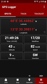
- Visualization of GPS information
- Manual Altitude Correction (adding an overall offset)
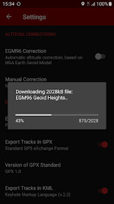
- Automatic Altitude Correction, based on NGA EGM96 Earth Geoid Model (you can enable it on Settings). If your device doesn't have Internet access, you can enable this feature manually by following this simple tutorial: https://www.basicairdata.eu/projects/android/android-gps-logger/application-note-gpslogger/manual-setup-of-the-egm-altitude-correction-for-basic-air-data-gps-logger/
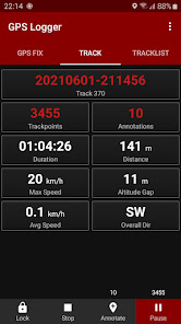
- Real time track statistics
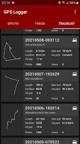
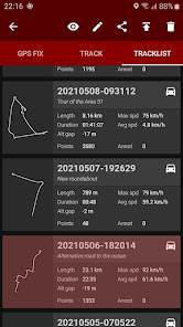
- In-app tracklist showing the list of recorded tracks
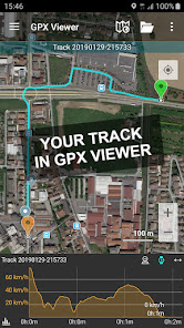
- Visualization of your tracks using any installed KML/GPX viewer, directly from the Tracklist
- Track exportation in KML, GPX, and TXT
- Track sharing, in KML, GPX, and TXT format, via E-mail, Dropbox, Google Drive, FTP, ...
- Uses Metric, Imperial, or Nautical units
USE IT TO:
☆ Keep track of your trips
☆ Make accurate static and dynamic measurements
☆ Add your placemarks
☆ Remember the best places you've seen
☆ GeoTag your photos
☆ Share your tracks with your friends
☆ Collaborate to OpenStreetMap map editing
LANGUAGES:
The translation of this app is based on users contribution. Everyone can freely help in translations using Crowdin (https://crowdin.com/project/gpslogger).
F.A.Q:
In case of any issue, you may find it helpful to read the frequently asked questions (https://github.com/BasicAirData/GPSLogger/blob/master/readme.md#frequently-asked-questions).
IMPORTANT NOTES:
In GPS Logger the Location is always accessed (started) when the App is in Foreground, and then is kept active also in background. On Android 10+ the app needs the Location permission "only while using the app". It doesn't need the "all the time" permission.
Depending on your Android Version, if you want to run GPS Logger reliably in background, you have to disable ALL the battery optimisations. For example you could verify in Android Settings, Apps, GPS Logger, Battery that the Background Activity is allowed and the Battery Usage is Not Optimised.
ADDITIONAL INFORMATION:
- Copyright © 2016-2022 BasicAirData - https://www.basicairdata.eu
- For additional information please see https://www.basicairdata.eu/projects/android/android-gps-logger/
- This program is free software: you can redistribute it and/or modify it under the terms of the GNU General Public License as published by the Free Software Foundation, either version 3 of the License, or (at your option) any later version. See the GNU General Public License for more details: https://www.gnu.org/licenses.
- You can view and download the source code of this app on GitHub: https://github.com/BasicAirData/GPSLogger
- When The EGM96 Automatic Correction is enabled for the first time into the Setting Screen, the file of the geoid heights is downloaded from the OSGeo.org website. (File size: 2 MB). Once downloaded, no further internet connection is required to use it.
It's a basic and lightweight GPS tracker focused on accuracy, with an eye to power saving.
It works offline (without internet connection), it has NO integrated maps.
This app is very accurate in determining the orthometric height (the altitude above sea level), if you enable EGM96 altitude correction on settings.
You can record all your trips, view them with any installed external viewer, directly from the in-app tracklist, and share them in KML, GPX, and TXT format in many ways.
The app is 100% Free and Open Source.
GETTING STARTED GUIDE:
https://www.basicairdata.eu/projects/android/android-gps-logger/getting-started-guide-for-gps-logger/
IT FEATURES:
- A modern UI, with a low consumption dark theme and a tabbed interface
- Offline recording (the app has no integrated maps)
- Foreground & Background Recording (On Android 6+ please turn off all battery monitoring and optimizations for this app)
- Creation of annotations also meanwhile recording
- Visualization of GPS information
- Manual Altitude Correction (adding an overall offset)
- Automatic Altitude Correction, based on NGA EGM96 Earth Geoid Model (you can enable it on Settings). If your device doesn't have Internet access, you can enable this feature manually by following this simple tutorial: https://www.basicairdata.eu/projects/android/android-gps-logger/application-note-gpslogger/manual-setup-of-the-egm-altitude-correction-for-basic-air-data-gps-logger/
- Real time track statistics
- In-app tracklist showing the list of recorded tracks
- Visualization of your tracks using any installed KML/GPX viewer, directly from the Tracklist
- Track exportation in KML, GPX, and TXT
- Track sharing, in KML, GPX, and TXT format, via E-mail, Dropbox, Google Drive, FTP, ...
- Uses Metric, Imperial, or Nautical units
USE IT TO:
☆ Keep track of your trips
☆ Make accurate static and dynamic measurements
☆ Add your placemarks
☆ Remember the best places you've seen
☆ GeoTag your photos
☆ Share your tracks with your friends
☆ Collaborate to OpenStreetMap map editing
LANGUAGES:
The translation of this app is based on users contribution. Everyone can freely help in translations using Crowdin (https://crowdin.com/project/gpslogger).
F.A.Q:
In case of any issue, you may find it helpful to read the frequently asked questions (https://github.com/BasicAirData/GPSLogger/blob/master/readme.md#frequently-asked-questions).
IMPORTANT NOTES:
In GPS Logger the Location is always accessed (started) when the App is in Foreground, and then is kept active also in background. On Android 10+ the app needs the Location permission "only while using the app". It doesn't need the "all the time" permission.
Depending on your Android Version, if you want to run GPS Logger reliably in background, you have to disable ALL the battery optimisations. For example you could verify in Android Settings, Apps, GPS Logger, Battery that the Background Activity is allowed and the Battery Usage is Not Optimised.
ADDITIONAL INFORMATION:
- Copyright © 2016-2022 BasicAirData - https://www.basicairdata.eu
- For additional information please see https://www.basicairdata.eu/projects/android/android-gps-logger/
- This program is free software: you can redistribute it and/or modify it under the terms of the GNU General Public License as published by the Free Software Foundation, either version 3 of the License, or (at your option) any later version. See the GNU General Public License for more details: https://www.gnu.org/licenses.
- You can view and download the source code of this app on GitHub: https://github.com/BasicAirData/GPSLogger
- When The EGM96 Automatic Correction is enabled for the first time into the Setting Screen, the file of the geoid heights is downloaded from the OSGeo.org website. (File size: 2 MB). Once downloaded, no further internet connection is required to use it.
Updated on
Safety starts with understanding how developers collect and share your data. Data privacy and security practices may vary based on your use, region, and age. The developer provided this information and may update it over time.

No data shared with third parties
Learn more about how developers declare sharing

No data collected
Learn more about how developers declare collection
Ratings and reviews
4.5
2.73K reviews

G Maas
- Flag inappropriate
January 11, 2021
Almost what I need. I want something that can stay on in the background forever and simply log. I can then use the GPS data to locate my photos. What is keeping me from GPS logger is that it can not log slower than once every 3 seconds. To be on all the time, I just need to be able to enter a number here (which will be 20-30 times slower but save a lot of power).
32 people found this review helpful
BasicAirData
May 22, 2024
The app has now a distance filter and an interval filter, that allows to record trackpoints less frequently. You can specify any time and distance numerical value, leaving the GPS update interval of 1s to have the maximum accuracy.

kadajawi
- Flag inappropriate
January 26, 2025
Its pretty good, fancier than the GPS logger I used previously (which sadly is gone). However that had the big advantage that the tracks are just somewhere in the file system. I don't have to manually export them... and there isn't even a select all feature. You need to figure out that by selecting the first, than scrolling to the bottom and long pressing the last track, you'll select all. Works, but could be easier.
55 people found this review helpful

Never Lamb
- Flag inappropriate
- Show review history
September 30, 2022
Simple but competent GPS logger. Doesn't cost too much battery. Very simple to use. It has 2 functions, record track and save waypoints. It doesn't have map, so you would need to export the tracks to other apps to view it. The app will detect biking, walking & driving and can export tracks to default locations. The only feature it missed is I hope it allow renaming of the tracks. Edit: It has rename function now, I want to give this review six stars, too bad it only allow me to set five stars.
61 people found this review helpful
What’s new
• Force recording the current trackpoint by holding down the Record button
• Added galician language
• Updated portuguese translation
• Upgraded to API 34 and updated dependencies
• Some UI refinements
• Added galician language
• Updated portuguese translation
• Upgraded to API 34 and updated dependencies
• Some UI refinements
App support
About the developer


